Places to See
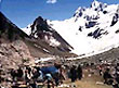
 Drass
Travel Guide
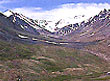
Drass (3230 m), 60 km west of Kargil on the road to Srinagar, is a small township
lying in the centre of the valley of the same name. It has become famous as
the second coldest inhabited place in the world by virtue of the intense cold
that descends upon the valley along with repeated snowfalls during winters.
Winter temperature is sometimes known to plummet to less than minus 40 degrees.
Click here to know more...
Drass
Travel Guide
Drass (3230 m), 60 km west of Kargil on the road to Srinagar, is a small township
lying in the centre of the valley of the same name. It has become famous as
the second coldest inhabited place in the world by virtue of the intense cold
that descends upon the valley along with repeated snowfalls during winters.
Winter temperature is sometimes known to plummet to less than minus 40 degrees.
Click here to know more...
------------------------------------------------------------------------------------------------------------------------------------------------------------------------------------------------------------------------------
 Gulmarg
Travel Guide
The meadow of Flowers is a world famous tourist spot in the Baramulla Distt
of Kashmir. The altitude of Gulmarg is 2730 meters. surrounded by dense forests
of tall conifers ,Gulmarg is known for unparalled beauty nad is rated as one
of the matchless tourist spots of the world.It is famous for Golf hikes and
boasts of a beautiful highland golf course. It is premier resort for winter
sports in the country.
Click
here to know more...
Gulmarg
Travel Guide
The meadow of Flowers is a world famous tourist spot in the Baramulla Distt
of Kashmir. The altitude of Gulmarg is 2730 meters. surrounded by dense forests
of tall conifers ,Gulmarg is known for unparalled beauty nad is rated as one
of the matchless tourist spots of the world.It is famous for Golf hikes and
boasts of a beautiful highland golf course. It is premier resort for winter
sports in the country.
Click
here to know more...
------------------------------------------------------------------------------------------------------------------------------------------------------------------------------------------------------------------------------
 Jammu
Travel Guide
Tucked away in the foothills of the Himalayas, with the picturesque river Tawi
flowing alongside, stands the land that Raja Jambu Lochan discovered one day
while he was hunting. Legend has it that he suddenly came upon a clearing where
he saw a sight that left him speechless. A tiger and a goat stood side by side
drinking water from the same place in the Tawi river. He was so struck by this
unsual sight that he decided to build a city on this soil where no-living creature
seemed to bear enmity towards each other.
Click
here to know more...
Jammu
Travel Guide
Tucked away in the foothills of the Himalayas, with the picturesque river Tawi
flowing alongside, stands the land that Raja Jambu Lochan discovered one day
while he was hunting. Legend has it that he suddenly came upon a clearing where
he saw a sight that left him speechless. A tiger and a goat stood side by side
drinking water from the same place in the Tawi river. He was so struck by this
unsual sight that he decided to build a city on this soil where no-living creature
seemed to bear enmity towards each other.
Click
here to know more...
------------------------------------------------------------------------------------------------------------------------------------------------------------------------------------------------------------------------------
 Kargil
Travel Guide
KARGIL (2704 m), 204 kms from Srinagar in the west and 234 kms from Leh in the
east, is the second largest urban centre of Ladakh and headquarters of the district
of same name. A quite town now, Kargil once served as important trade and transit
centre in the Pan-Asian trade network. Numerous caravans carrying exotic merchandise
comprising silk, brocade, carpets, felts, tea, poppy, ivory etc. transited in
the town on their way to and from China, Tibet, Yarkand and Kashmir. The old
bazaar displayed a variety of Central Asian and Tibetan commodities even after
the cessation of the Central Asian trade in 1949 till these were exhausted about
two decades back.
Click
here to know more...
Kargil
Travel Guide
KARGIL (2704 m), 204 kms from Srinagar in the west and 234 kms from Leh in the
east, is the second largest urban centre of Ladakh and headquarters of the district
of same name. A quite town now, Kargil once served as important trade and transit
centre in the Pan-Asian trade network. Numerous caravans carrying exotic merchandise
comprising silk, brocade, carpets, felts, tea, poppy, ivory etc. transited in
the town on their way to and from China, Tibet, Yarkand and Kashmir. The old
bazaar displayed a variety of Central Asian and Tibetan commodities even after
the cessation of the Central Asian trade in 1949 till these were exhausted about
two decades back.
Click
here to know more...
------------------------------------------------------------------------------------------------------------------------------------------------------------------------------------------------------------------------------
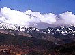
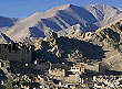
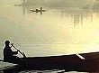
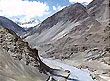
 Ladakh
Travel Guide
Ladakh is a land like no other. Bounded by two of the world's mightiest mountain
ranges, the Great Himalaya and the Karakoram, it lies athwart two other, the
Ladaksh range and the Zanskar range. In geological terms, this is a young land,
formed only a few million years ago by the buckling and folding of the earth's
crust as the Indian sub-continent pushed with irresistible force against the
immovable mass of Asia. Its basic contours, uplifted by these unimaginable tectonic
movements, have been modified over the millennia by the opposite process of
erosion, sculpted into the form we see today by wind and water.
Click
here to know more...
Ladakh
Travel Guide
Ladakh is a land like no other. Bounded by two of the world's mightiest mountain
ranges, the Great Himalaya and the Karakoram, it lies athwart two other, the
Ladaksh range and the Zanskar range. In geological terms, this is a young land,
formed only a few million years ago by the buckling and folding of the earth's
crust as the Indian sub-continent pushed with irresistible force against the
immovable mass of Asia. Its basic contours, uplifted by these unimaginable tectonic
movements, have been modified over the millennia by the opposite process of
erosion, sculpted into the form we see today by wind and water.
Click
here to know more...
------------------------------------------------------------------------------------------------------------------------------------------------------------------------------------------------------------------------------
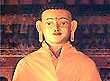
 Leh
Travel Guide
The main town of the region, is dominated by Sengge Namgyal's nine-storey Palace,
a building in the grand tradition of Tibetan architecture, said to have inspired
the famous Potala in Lhasa, which was built half a century later. Above it,
on Namgyal Tsemo, the peak overlooking the town, are the ruins of the earliest
royal residence at Leh, a fort built by King Tashi Namgyal in the 16th century.
The associated temples remain intact, but they are kept locked except during
the morning and evening hours when a monk toils up the hills from Sankar Gompa
to attend to the butter-lamps in front of the images.
Click
here to know more...
Leh
Travel Guide
The main town of the region, is dominated by Sengge Namgyal's nine-storey Palace,
a building in the grand tradition of Tibetan architecture, said to have inspired
the famous Potala in Lhasa, which was built half a century later. Above it,
on Namgyal Tsemo, the peak overlooking the town, are the ruins of the earliest
royal residence at Leh, a fort built by King Tashi Namgyal in the 16th century.
The associated temples remain intact, but they are kept locked except during
the morning and evening hours when a monk toils up the hills from Sankar Gompa
to attend to the butter-lamps in front of the images.
Click
here to know more...
------------------------------------------------------------------------------------------------------------------------------------------------------------------------------------------------------------------------------
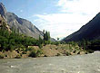
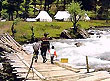 Pahalgam
Travel Guide
The Village of nomad is unspoilt by the ravages of progress. This is a quaint
little village nestled on the banks of river Lidder. This place is an angler's
delight and even an amateur can catch a rainbow trout from the rushing streams.
the large brown bear is a natural inhabitant of the thick Pine and Cedar forests.
Pahalgam has a golf course at 2400 meters above the sea level. Camping equipment,
ponies and skiing equipment is readily available. Kolahoi is a popular destinantion
via Aru a charming meadow. Pahalgam is base camp for the pilgrims of Amarnath.
Click
here to know more...
Pahalgam
Travel Guide
The Village of nomad is unspoilt by the ravages of progress. This is a quaint
little village nestled on the banks of river Lidder. This place is an angler's
delight and even an amateur can catch a rainbow trout from the rushing streams.
the large brown bear is a natural inhabitant of the thick Pine and Cedar forests.
Pahalgam has a golf course at 2400 meters above the sea level. Camping equipment,
ponies and skiing equipment is readily available. Kolahoi is a popular destinantion
via Aru a charming meadow. Pahalgam is base camp for the pilgrims of Amarnath.
Click
here to know more...
------------------------------------------------------------------------------------------------------------------------------------------------------------------------------------------------------------------------------
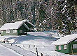
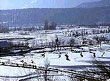 Patnitop
Travel Guide
112 kms from Jammu. This famous hill resort is perched on a beautiful plateau,
at an altitude of 2024 metres across which the Jammu-Srinagar Highway passes.
Patnitop
Travel Guide
112 kms from Jammu. This famous hill resort is perched on a beautiful plateau,
at an altitude of 2024 metres across which the Jammu-Srinagar Highway passes.
Enveloped by thickly wooded forests,Patnitop offers beautiful picnic spots,
peaceful walks and breathtaking views of the mountainscape of the Chenab basin.
In winter, the resort is generally covered with athick mantle of snow thus providing
opportunities for various snow games includingskiing. It is the best developed
tourist spot of Jammu and is second to none in its natural charm, climate, pine
forests and lush green cover.
Click
here to know more...
------------------------------------------------------------------------------------------------------------------------------------------------------------------------------------------------------------------------------
 Sonamarg
Travel Guide
The Golden Meadow is at an altitude of 2740 meters and is gateway to Ladakh.It
has brilliant forests of sycamore and alpine flowers, silver birch,fir and pine;
Sonamarg is a place of enthralling beauty. Three lakes viz Kishensar,Vishensar
and Gangabal can be viewed from Nichnai Pass. 20 Kms east of Sonamarg is Zoji-La
Pass at 3540 mtrs which leads into Ladakh Plateau.
Click
here to know more...
Sonamarg
Travel Guide
The Golden Meadow is at an altitude of 2740 meters and is gateway to Ladakh.It
has brilliant forests of sycamore and alpine flowers, silver birch,fir and pine;
Sonamarg is a place of enthralling beauty. Three lakes viz Kishensar,Vishensar
and Gangabal can be viewed from Nichnai Pass. 20 Kms east of Sonamarg is Zoji-La
Pass at 3540 mtrs which leads into Ladakh Plateau.
Click
here to know more...
------------------------------------------------------------------------------------------------------------------------------------------------------------------------------------------------------------------------------
 Srinagar
Travel Guide
Srinagar, the state capital, is situated at an altitude of 1,730 meters above
sea level. It is connected by Indian Airlines and Jet Airways flights directly
to Jammu and New Delhi, and hence to every part of the national network. An
all-weather road to Jammu, which in turn is connected, too many parts of North
India connects Srinagar. Srinagar's nearest railhead is Jammu, which in turn
connects all parts of the country, including Delhi, Kolkata, Pune, Murnbai
and Kanyakumari, Kashmir receives most of its rainfall in spring.
Click
here to know more...
Srinagar
Travel Guide
Srinagar, the state capital, is situated at an altitude of 1,730 meters above
sea level. It is connected by Indian Airlines and Jet Airways flights directly
to Jammu and New Delhi, and hence to every part of the national network. An
all-weather road to Jammu, which in turn is connected, too many parts of North
India connects Srinagar. Srinagar's nearest railhead is Jammu, which in turn
connects all parts of the country, including Delhi, Kolkata, Pune, Murnbai
and Kanyakumari, Kashmir receives most of its rainfall in spring.
Click
here to know more...
------------------------------------------------------------------------------------------------------------------------------------------------------------------------------------------------------------------------------
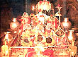 Vaishno
Devi Travel Guide
Located at a height of 5300 feet on holy Trikuta Hills. The holy cave shrine
of Mata Vasihnodevi Ji is one of the most popular Shrines of the country. The
Goddess Vaishnodevi's abode is in a 100 feet long cave with a narrow opening.
The holy Ganga's cold and crystal clear water washes the lotus feet of the mata's'
Pindian'. There are three natrual pindies of Maha Saraswati, Maha Lakshmi and
Mahakali which represent creative, preservative and destructive aspects of the
divine energy.
Click
here to know more...
Vaishno
Devi Travel Guide
Located at a height of 5300 feet on holy Trikuta Hills. The holy cave shrine
of Mata Vasihnodevi Ji is one of the most popular Shrines of the country. The
Goddess Vaishnodevi's abode is in a 100 feet long cave with a narrow opening.
The holy Ganga's cold and crystal clear water washes the lotus feet of the mata's'
Pindian'. There are three natrual pindies of Maha Saraswati, Maha Lakshmi and
Mahakali which represent creative, preservative and destructive aspects of the
divine energy.
Click
here to know more...
------------------------------------------------------------------------------------------------------------------------------------------------------------------------------------------------------------------------------
 Zangla
Travel Guide
Lying deep in the northern arm of Zanskar at the end of the 35 km. Long rough
road from Padum, Zangla was being ruled by a titular king till his death a few
years back. The old castle now in ruins except from a small chappel, occupies
a hill, overlooking the desertic valley below. Nearby is the old Nunnery worth
a visit for the austere life style of the small monastic community of nuns.
Click
here to know more...
Zangla
Travel Guide
Lying deep in the northern arm of Zanskar at the end of the 35 km. Long rough
road from Padum, Zangla was being ruled by a titular king till his death a few
years back. The old castle now in ruins except from a small chappel, occupies
a hill, overlooking the desertic valley below. Nearby is the old Nunnery worth
a visit for the austere life style of the small monastic community of nuns.
Click
here to know more...
------------------------------------------------------------------------------------------------------------------------------------------------------------------------------------------------------------------------------
 Zanskar
Travel Guide
About 20 kms. South of Rangdum stands the Pazila watershed across which lies
Zanskar, the most isolated of all the trans Himalayan Valleys. The Panzila Top
(4401 m) is the picturesque tableland adorned with two small alpine lakes and
surrounded by snow covered peaks. As the Zanskar road winds down the steep slopes
of the watershed to the head of the Stod Valley, one of Zanskar's main tributary
valleys, the majestic "Drang-Drung" glacier looms into full view.
Click
here to know more...
Zanskar
Travel Guide
About 20 kms. South of Rangdum stands the Pazila watershed across which lies
Zanskar, the most isolated of all the trans Himalayan Valleys. The Panzila Top
(4401 m) is the picturesque tableland adorned with two small alpine lakes and
surrounded by snow covered peaks. As the Zanskar road winds down the steep slopes
of the watershed to the head of the Stod Valley, one of Zanskar's main tributary
valleys, the majestic "Drang-Drung" glacier looms into full view.
Click
here to know more...